Dr. Alicia M. Kinoshita and Lauren Mathews, San Diego State University
November 6, 2019
With wildfire frequency and size increasing across the western United States, human-ignited fires, drought, large fuel loads and non-native vegetation have made urban waterways into corridors for fire movement. Human activities and burned areas can alter water and soil processes, which may further contribute to degraded water quality. Yet urban fire processes are not well documented and very little is known about the impacts on local ecosystems, especially in Mediterranean and coastal stream systems like those found in southern California. To increase our knowledge of urban fire processes and their impacts on coastal watersheds, this study aims to advance our understanding of post-fire vegetation, soil and stream interactions using a combination of field, remote sensing and modeling methods in urban riparian zones. Riparian zones are vegetated areas adjacent to rivers and streams that serve as buffers between upland areas and water bodies. They naturally filter inputs to streams such as soil and pollutants, including nutrients and heavy metals. Thus, riparian zones may be important regulators of secondary post-fire impacts such as altered pollutant fluxes and increased soil erosion.
.jpg)
Del Cerro Fire burned palm trees along Alvarado Creek and chaparral on the hillslope (June 2018).
In June 2018, the Del Cerro Fire burned a substantial portion of the riparian zone in Alvarado Creek, a tributary of the San Diego River that drains to the Pacific Ocean. Alvarado Creek has groundwater and surface water interactions, which contribute to brackish and perennial characteristics. The human-ignited brush fire was fueled primarily by highly invasive plants such as
Arundo donax and
Washingtonia
spp., which are prevalent in the San Diego River Watershed. This event presented us with the opportunity to study vegetation recovery, soil erosion and hydrology in coastal semi-arid watersheds following urban fires. Our study objectives were to 1) estimate the sediment contribution from the upland hillslope to the riparian zone and creek and 2) assess the effect of invasive riparian vegetation on sediment and stream processes. Work was conducted in the 12 months following the fire to track changes in the watershed throughout the rainy season.
Arundo donax May-July 2018 (top), and
Arundo donax
regrowth July-November 2018 (bottom).
Most of the vegetation density lost due to the Del Cerro Fire occurred in the riparian corridor along Alvarado Creek. Qualitative observations of post-fire recovery in the study area from July to November 2018 showed a rapid regrowth of invasive plants in the riparian zone adjacent to Alvarado Creek and comparably slower to non-existent regrowth of native species in riparian and upland areas.
Using satellite imagery to determine the amount of vegetation present before and after the fire, we estimated a moderate burn severity in the riparian areas and low burn severity in the upland areas. From May (pre-fire) to July 2018 (post-fire), the average relative change for riparian vegetation decreased by 40±18% (ave.
± SE) and upland vegetation decreased by 33±20%. From July to November 2018 (prior to the first winter storm), the average relative change for riparian vegetation increased by 16% (compared to pre-fire vegetation conditions), while the upland vegetation decreased by 1%. The rapid regrowth in the riparian zone was primarily observed in areas with invasive species. For example, areas with large concentrations of non-native vegetation experienced an 18-57% decrease in vegetation immediately after the fire. Within five months there was up to an 80% increase in
Arundo donax without any significant rainfall.
To observe changes in the landscape and stream channel morphology during the post-fire wet season, we conducted field work before, during and after the storm season (October 2018, January 2019 and May 2019, respectively). Lauren Mathews, a SDSU M.S. thesis student, led a team of SDSU students and volunteers to survey stream channels and measure hydraulic conductivity, soil moisture, canopy cover and grain size distributions.
We used high-resolution terrestrial laser scanning (TLS) to capture detailed images of the landscape. Each scan is conducted on the same section of hillslope that encompasses the area immediately adjacent to Alvarado Creek. Successive TLS images will be used to document the storage and supply of soil with respect to native and non-native vegetation and hydrologic conditions. Future scans will continue to provide information on volumetric soil change with respect to vegetation and rainfall.
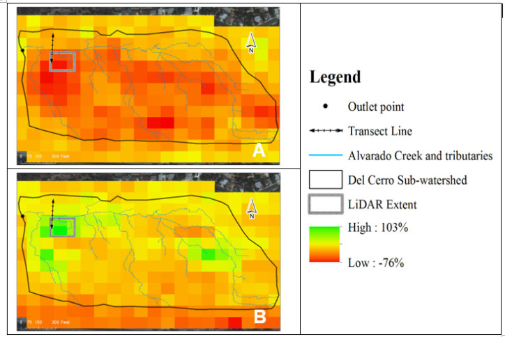
The Del Cerro study site shown with the normalized difference vegetation index (NDVI).
Preliminary results and analysis suggest that
Arundo donax impacts sediment and hydrologic regimes following fires. There was more variability in the elevation of the land surface surrounding the stands of
Arundo donax adjacent to Alvarado Creek than in areas characterized by native vegetation. Decreasing elevation suggests that along with geomorphic change, sediment volume was lost from
Arundo donax dominated areas. Preliminary results indicate that there were minimal changes in sediment transported from the native vegetated hillslopes compared to areas that had
Arundo donax stands. This work is representative of processes that can occur in urban waterways. It is especially important as the risk for fires increases due to the build-up of non-native and flammable vegetation and opportunities for human ignition sources from the headwaters to the coast. Further, our limited understanding of altered sediment processes from areas dominated by non-native vegetation in burned riparian areas is limited. Yet, these processes have significant implications for the delivery of sediment and contaminants to the coast.
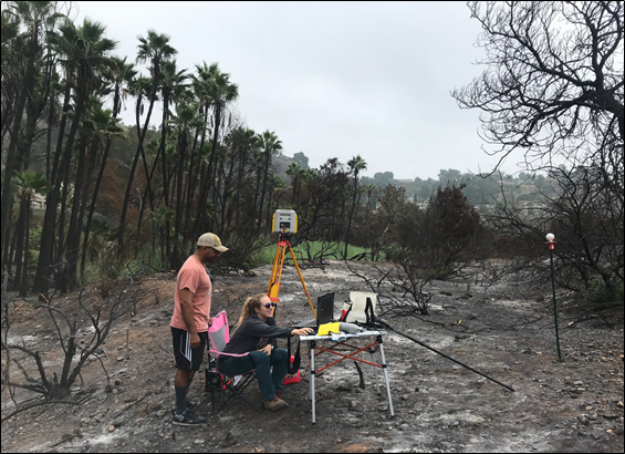
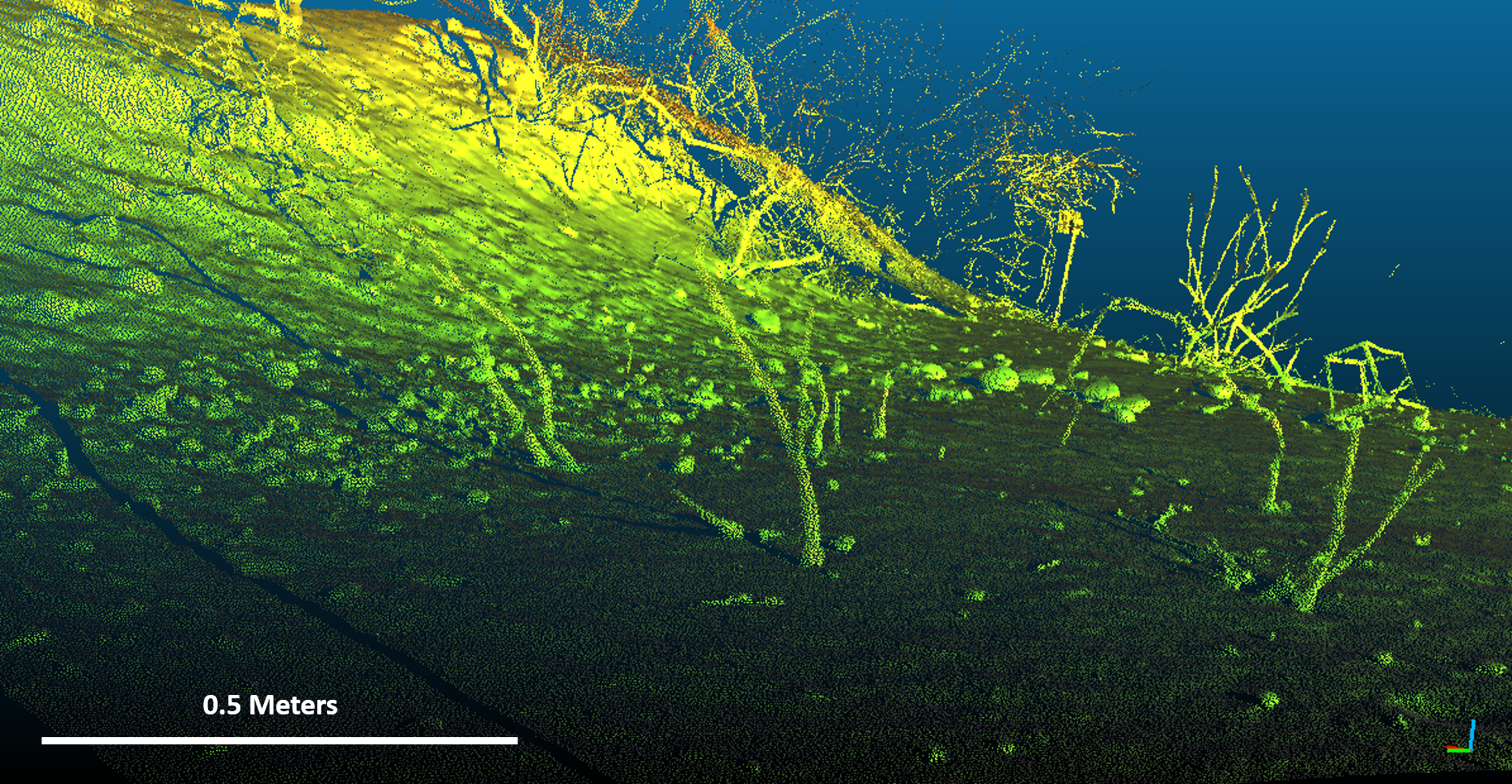
Lauren Mathews and Deryk Godinez use high-resolution terrestrial laser scanning (TLS) after the fire in October 2018 to provide detailed images of the burned landscape (top). TLS image of a burned upland slope with chaparral (bottom).
Ongoing and future field surveys following the 2018-2019 storm season and during the 2019-2020 storm season will provide additional information that will help us better understand the burned environment and its recovery. This research will be incorporated into hydrologic models to predict soil and water processes, which can lead to poor water quality following fires. Ultimately, this work will inform and improve recovery and management of burned urban riverine systems.
This research included the voluntary efforts of numerous San Diego State University (SDSU) undergraduate and graduate student participants in the field: Valerio Ruchay, Jack Mikesell, Quinn Walker, Rey Becerra, Kevin O’Marah, Sam Zorn, Nathan Harrison, Rosie Forgey, Kyler Stevenson, Kelly Flint, Sarah Mondloch and Minerva Munoz.
Research presentations by Lauren Mathews that directly resulted from this project include the 2018 San Diego State University Student Research Symposium (SRS), 2018 American Geophysical Union (AGU) Fall Meeting in Washington, D.C., and 2019 International Erosion Control Association (IECA) Annual Meeting in Denver, CO. Data also supported the development of a model using Loading Simulation Program in C++ (LSPC) to simulate hydrology, sediment, and general water quality before and after the fire. Preliminary results were presented by Jack Mikesell at the 2019 IECA Annual Meeting and the 2019 SDSU SRS. This work provided preliminary results for a National Science Foundation CAREER Program Award to A. Kinoshita (Grant No.
1848577).
Dr. Alicia M. Kinoshita is an Associate Professor in the Department of Civil, Construction, and Environmental Engineering (CCEE) at San Diego State University. Lauren Mathews is a graduate student in the Environmental Engineering program in CCEE. COAST provided funding for this project through a
Rapid Response Funding Program
Award# COAST-RR-2017-04, August 2017 and Graduate Student Research Award# CSUCOAST-MATLAU-SDSU-AY1718, February 2018.